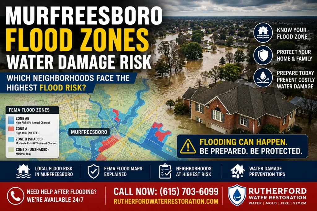
Murfreesboro, Tennessee is not a city most people associate with flood risk — but the numbers tell a different story. Rutherford County records several hundred water damage murfreesboro insurance claims each year tied directly to flooding events, and FEMA’s current flood maps designate significant portions of the city as elevated-risk zones. If you own a home in Murfreesboro Flood Zones water damage risk and have never looked up your flood zone designation, this guide will walk you through exactly what those designations mean, which neighborhoods carry the most risk, and what to do if water gets into your home.
This is not a generic national flood guide. Every neighborhood, street reference, and risk factor in this article is specific to Murfreesboro and Rutherford County.
What FEMA flood zones actually mean for water damage Murfreesboro tn first 24 hours homeowners
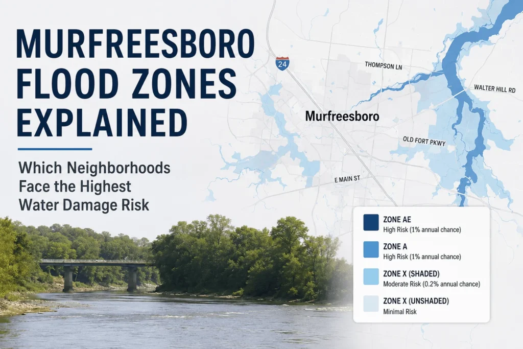
FEMA maintains the National Flood Insurance Program (NFIP) and publishes official Flood Insurance Rate Maps (FIRMs) for every county in the United States. Rutherford County’s current FIRM was last updated and is accessible through FEMA’s Flood Map Service Center at msc.fema.gov. Your specific property’s flood zone designation determines whether lenders require you to carry flood insurance and, more practically, how likely your home is to experience flood-related water damage.
The most important designations to understand for Murfreesboro Flood Zones water damage risk homeowners are:
- Zone AE: The highest-risk category. These areas have a 1% annual chance of flooding — often called the ‘100-year flood plain.’ Mortgage lenders require flood insurance for properties in Zone AE. Murfreesboro’s Zone AE areas are concentrated along the Stones River mainstem and its primary tributaries.
- Zone A: Similar risk to AE but without detailed base flood elevation data. Also requires flood insurance. Found in some rural parts of Rutherford County and along secondary drainage corridors in the eastern city limits.
- Zone X (Shaded): Moderate risk — a 0.2% annual chance of flooding, or what is called the ‘500-year flood plain.’ No mandatory insurance requirement, but flooding can and does occur. Many Murfreesboro homeowners in shaded Zone X areas have experienced water intrusion events.
- Zone X (Unshaded): Considered minimal risk based on current mapping. Important caveat: flood maps do not update instantly when development changes drainage patterns, and Murfreesboro’s rapid construction has altered surface water behavior in ways that current maps may not fully reflect.
| Important caveat for homeowners in new subdivisions Flood maps lag behind development by years. New construction in Blackman, Cason Lane, and other rapidly developing western Murfreesboro communities has changed how surface water moves. Homes in officially designated low-risk zones can still experience water intrusion if lot grading, storm sewer capacity, or upstream development has altered drainage. Low-risk designation does not mean zero risk. |
Which Murfreesboro neighborhoods carry the highest flood risk
Using FEMA flood map data, local topographic information, and our team’s direct field experience across Rutherford County, these are the areas of Murfreesboro where residents are most likely to encounter flooding and water damage events:
Walter Hill and the Stones River corridor
Walter Hill Road and the rural and semi-rural properties immediately adjacent to the Stones River northeast of Murfreesboro’s city center carry the highest flood risk of any Murfreesboro-area community. The Stones River in this section flows through a relatively flat valley, and during significant rain events — particularly following wet ground saturation in late winter and spring — river levels rise quickly. Properties on the low-lying east bank of the river between Walter Hill and the Murfreesboro corporate limits have experienced flooding multiple times within the past decade.
Homeowners near Walter Hill Road, Burnt Knob Road, and the Stones River Greenway trail corridor should treat spring storm forecasts seriously. Even a relatively moderate storm can push river levels to flood stage when the ground is already saturated from earlier precipitation.
Northeastern Murfreesboro — the Thompson Lane and Old Fort Parkway drainages
The northeastern portion of Murfreesboro, bounded roughly by Thompson Lane to the north and Old Fort Parkway to the south, drains toward the Stones River through a network of engineered channels and natural creek systems. Several of these channels were sized based on historical development density that has since been significantly exceeded. During heavy rain events, overflow from these drainage channels can back up into low-lying residential areas, particularly in neighborhoods built in the 1970s and 1980s when the surrounding area was less developed.
Homeowners in this corridor who experience recurring basement dampness or water intrusion through foundation walls during heavy rains are often dealing with drainage system capacity issues rather than plumbing failures. The distinction matters for both the repair approach and the applicable insurance coverage.
Blackman and western Murfreesboro — grading and drainage issues in new construction
The Blackman area and the broader western Murfreesboro growth corridor between Murfreesboro and Smyrna do not fall primarily within FEMA’s highest-risk zones — but new construction water damage has become increasingly common here for a different reason. When large subdivisions are graded and developed rapidly, individual lot drainage is sometimes completed incorrectly. Homes where the surrounding grade slopes toward the foundation walls rather than away from them will experience water intrusion through foundation walls, garage floors, and crawl space vents during any significant rainfall, regardless of flood zone designation.
This is one of the most commonly misunderstood water damage scenarios in Murfreesboro. Homeowners in newer Blackman subdivisions who experience water in their garage or crawl space after every heavy rain are typically dealing with a grading or drainage design problem — not a defective foundation. The solution is different from what many restoration companies will tell you.
Zip codes 37127 and 37130 — eastern and central areas
The eastern portions of Murfreesboro in zip code 37127, including the areas south and east of the Stones River Greenway, carry moderate flood risk from the river’s eastern drainage. Properties within approximately half a mile of the river in this zip code should consult FEMA’s maps for their specific parcel before assuming they are in an unshaded Zone X.
Zip code 37130 includes central Murfreesboro, which sits at higher elevation than the river corridor areas. The primary water damage risk in 37130 is from urban stormwater — the city’s aging storm sewer infrastructure in its older commercial and residential districts can back up during intense rainfall events, pushing water into basement window wells and lower-level entry points.
The risk that flood maps miss: Tennessee’s humidity and mold timeline
Even for homeowners outside FEMA’s designated flood zones, Murfreesboro’s climate creates a water damage complication that most national resources understate. Middle Tennessee averages relative humidity of 70 to 80 percent during the summer months. At these humidity levels, mold colonies can begin establishing themselves within 24 hours of a water intrusion event — not the 48 hours cited in national guidelines written for drier climates.
This matters because the standard advice of ‘clean it up and let it dry’ underestimates how quickly a problem can develop in a Murfreesboro home. A wet carpet or saturated wall cavity that would be recoverable in Colorado or Arizona can develop active mold growth overnight in July in Rutherford County. If your home experiences any water intrusion — whether from a pipe failure, storm drainage backup, or ground water — the clock starts immediately.
What to do if your Murfreesboro home floods
The actions you take in the first hour after a water event determine a significant portion of the total restoration cost. These steps apply whether you are in a designated flood zone or experienced an unexpected water intrusion in a lower-risk area:
- Stop the source if possible. If the water is coming from a plumbing failure, shut off the main water supply to the home. The shutoff valve is typically near the water meter, which in most Murfreesboro homes is located at the street property line or in a utility area near the water heater.
- Do not use electrical systems. If water has reached electrical outlets, the breaker panel, or any wiring, treat the affected areas as live hazards until a qualified electrician confirms safety. Water and electricity is the primary safety risk in a flooding event.
- Document everything before moving anything. Take photos and video of all affected areas, standing water levels, and visible damage before touching or moving anything. This documentation is essential for any property claim process. Photograph from multiple angles and include something in the frame that establishes scale.
- Move valuables to dry areas. Items stored at floor level — boxes, furniture, electronics — should be moved to dry rooms or elevated surfaces to prevent additional damage. Do not put items in areas that are showing any signs of moisture.
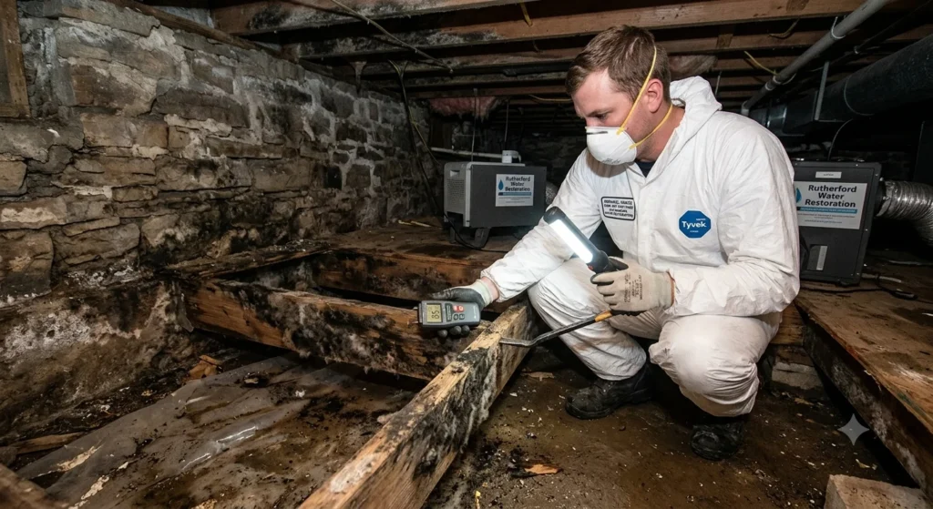
- Contact a professional restoration team. Industrial water extraction and drying equipment operates at a completely different scale than consumer equipment. A shop vac removes surface water; it does not extract moisture from subfloor materials, wall cavities, or insulation. Professional equipment is not optional for any water intrusion beyond a minor surface spill.
| Why the first hour matters so much Water migrates faster than most homeowners expect. In the first 60 minutes after a significant water event, water moves through wall cavities via capillary action, soaks into subfloor materials, begins saturating insulation, and wicks into furniture bases. Actions taken in the first hour — particularly beginning extraction — have a measurable impact on total restoration scope and cost.murfreesboro flood zones water damage risk |
How to look up your specific flood zone in Murfreesboro
To look up the official FEMA flood zone designation for a specific property address in Murfreesboro or Rutherford County:
- Go to FEMA’s Flood Map Service Center at msc.fema.gov
- Enter your Murfreesboro address in the search field
- The map will display the flood zone designation for your specific parcel
- Rutherford County is under FEMA map panel number 47149, if you need to reference it directly
You can also contact the Rutherford County Planning and Zoning office, which maintains local flood zone records and can provide parcel-specific information for properties that sit on zone boundaries.
Is Murfreesboro TN in a flood zone?
Parts of Murfreesboro are in FEMA-designated flood zones, primarily Zone AE and Zone A areas along the Stones River corridor and its tributaries. Not all of Murfreesboro is in a high-risk zone. You can look up any specific address at msc.fema.gov to determine the official designation for that property.
Does the Stones River flood in Murfreesboro?
Yes. The Stones River rises during significant rain events and has caused documented flooding in adjacent properties on multiple occasions. The river’s behavior is most notable in the Walter Hill area and in lower-elevation areas northeast of Murfreesboro’s city center. Spring months — particularly April and May — carry the highest flood risk when the ground is already saturated.
Do I need flood insurance if my Murfreesboro home is in Zone X?
Zone X is officially considered a moderate-to-low risk designation. Flood insurance is not legally required for Zone X properties with conventional mortgages, but flooding can still occur. Murfreesboro’s rapid development has changed surface water behavior in ways that FEMA maps may not yet reflect. Homeowners in Zone X who have experienced any water intrusion during heavy rains may want to consult with their property carrier about available coverage.
What is the most common cause of water damage in Murfreesboro?
Based on claims patterns across Rutherford County, the most common causes are plumbing failures — burst pipes, water heater failures, and appliance leaks — for residential properties, and storm-related water intrusion for highest-dollar-value events. New construction drainage issues have become an increasing contributor in the Blackman and western Murfreesboro growth corridors.
How quickly does mold develop after water damage in Murfreesboro?
In Murfreesboro’s climate, with summer relative humidity averaging 70 to 80 percent, mold can begin establishing within 24 hours of a significant water intrusion event. This is faster than national guidelines that assume average humidity conditions. Any water intrusion should be addressed by a professional restoration team as quickly as possible.
Related resources on rutherfordwaterrestoration.com:
- Emergency water damage response in Murfreesboro — /services/emergency-water-damage-murfreesboro/
- Water damage restoration in Murfreesboro TN — /locations/murfreesboro-tn/
- Mold remediation Murfreesboro TN — /services/mold-remediation-murfreesboro-tn/
- Structural drying and dehumidification — /services/structural-drying-dehumidification/